Cima Cerro Muñeco (Route test 3)
Cima Cerro Muñeco (Route test 3)
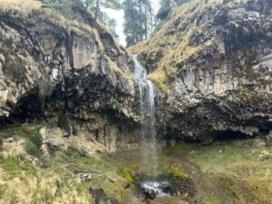
Standing at the summit of Cerro Muñeco with my bike, the city below vanished behind a sea of oyamel fir and the clean, sharp air of the Desierto de los Leones. The punishing climb up through the ancient forest, over roots and volcanic rock, all fades away in an instant. Up here, suspended between the sprawling chaos of Mexico City and the vast silence of the mountains, you don't just feel like you've earned the view—you feel like you've discovered a secret.
Here are 3-5 paragraphs of placeholder text describing the experience of mountain biking to Cerro Muñeco in the Desierto de los Leones.
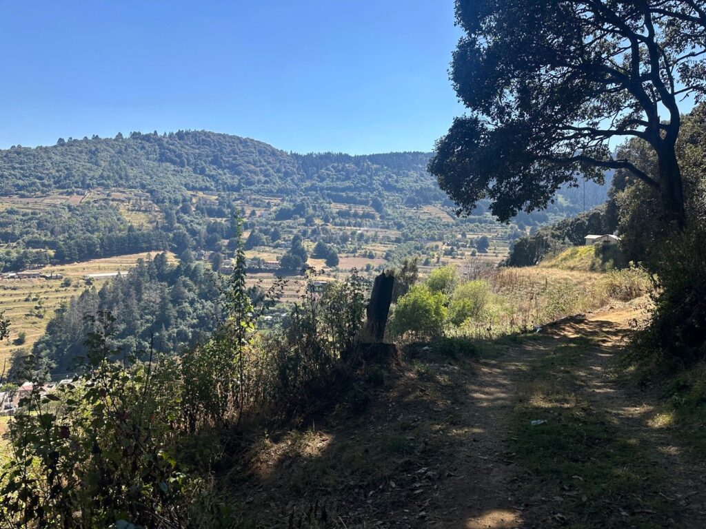
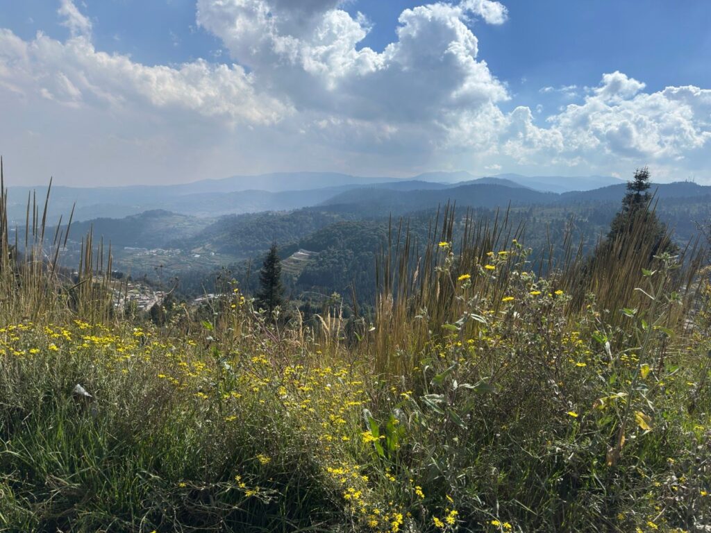
The day begins in the cool, thin air of Mexico City, a welcome reprieve from the valley’s usual haze. Pedaling away from the last insistences of the urban sprawl, the entrance to the Desierto de los Leones National Park feels like a true gateway. The initial approach is a gradual awakening of the senses; the scent of damp earth and pine begins to replace the city’s exhaust, and the noise of traffic fades into a distant hum. The tires roll over a carpet of fallen needles, and the real work begins. The climb is immediate and unrelenting, a winding snake of dirt and rock that disappears into a cathedral of ancient, towering oyamel firs. Each push on the pedals is a negotiation with gravity, a rhythmic effort that warms the muscles against the mountain’s cool embrace.
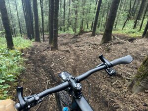
As you ascend, the forest deepens and closes in around you. Shafts of sunlight pierce the dense canopy, illuminating the dust kicked up by your tires and the vibrant green of the moss clinging to the trees’ gnarled bark. The trail, part of the old network of roads within this historic park, becomes a test of focus and stamina. You’re no longer just riding; you’re navigating a labyrinth of loose rocks and exposed roots that demand constant attention. The only sounds are the crunch of your tires, the soft whir of the drivetrain, and your own controlled breathing. It’s a solitary communion with the landscape, a physical meditation where the mind clears with every hard-won meter of altitude gained on the push toward Cerro Muñeco.
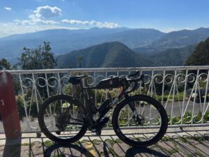
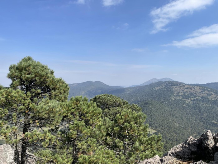
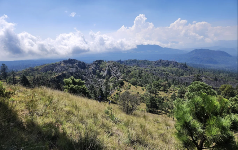
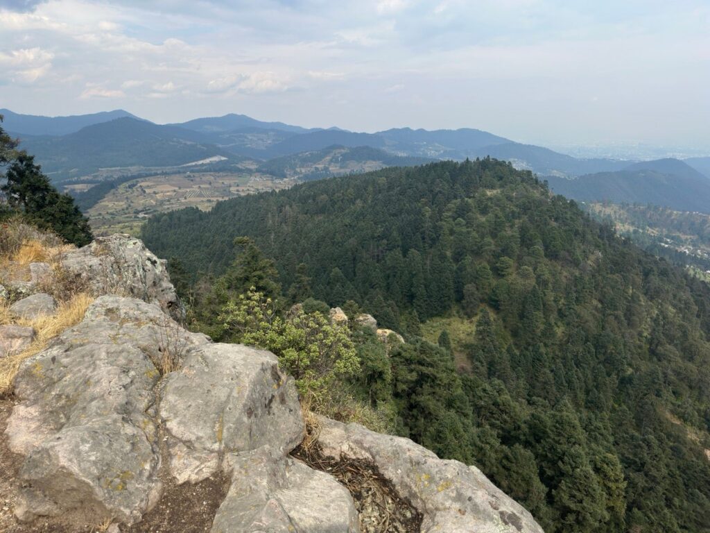
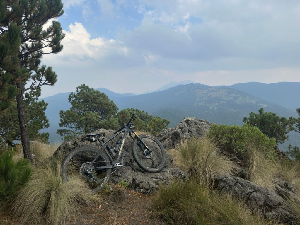
Breaking through the treeline near the summit of Cerro Muñeco is a moment of pure revelation. The exertion of the climb is instantly rewarded by a panorama that steals the breath you’ve just labored to regain. Below, the dense green blanket of the Desierto de los Leones stretches out, a startling oasis of wilderness cradled in the volcanic mountains. Beyond it, the sprawling enormity of Mexico City unfolds, a hazy grid of life and activity that feels utterly detached from this serene perch. Here, standing with your bike at over 3,800 meters, you are on top of the world, or at least on top of this particular corner of it. The wind, crisp and clean, carries the silence of the high mountains, a perfect counterpoint to the city below.
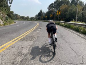
But the mountain is not finished. The ride down is a different kind of thrill, a high-speed, adrenaline-fueled descent that demands as much skill as the climb did effort. The trail transforms into a playground of possibilities. You flow over the rocks and roots that were obstacles moments ago, leaning into berms and feathering the brakes to maintain control. The forest blurs past in a streak of green and brown, the cool air rushing against your face. It’s a pure, physical joy, a dance with gravity that brings you swiftly and exhilaratingly back toward the park’s entrance, leaving you with the lingering memory of the heights and the satisfying ache of a day spent in the saddle.
Route Difficulty
Route Difficulty Title example
The cycling route to Cerro Muñeco within the Desierto de los Leones is considered exceptionally challenging, demanding a high level of physical fitness and technical skill. The ascent is relentless, featuring steep, uneven gradients that test a rider’s endurance and power output on a sustained climb. The terrain is a mix of broken pavement and sections of loose gravel and dirt, requiring constant attention to maintain traction and navigate unpredictable surfaces. This combination of high-altitude physical strain and technical terrain makes the route a formidable endeavor, suitable only for experienced cyclists.
Why is this route relevant?
Beyond its cultural cachet, the route is a practical high-altitude training ground used by everyone from weekend warriors to world-class professional cyclists. The thin air at 3,000 meters forces the body to work harder with less oxygen, providing a unique physiological challenge that is difficult to find elsewhere without traveling deep into remote mountain ranges. Furthermore, the route encapsulates the unique identity of Mexico City cycling: a gritty blend of urban fringe and untamed wilderness. You start in the dusty, windswept plains of La Marquesa, suffer through dense, misty forests, and emerge back into the chaos of the city. It is relevant because it tells the story of the local landscape—a constant push and pull between the concrete jungle and the ancient mountains that surround it.
⚠️ Safety Notice
Along the climb out of San Pedro Altapulco (where the forest road starts), until closer to the peak of Cerro Muñeco. To the south of this zone can be dangerous due to Talamontes, and logging activity. Maintain vigilance.
Recommended Start: <p>6am / 9am Maximum. 4/5am from CDMX.</p>
Time Restrictions: <p>I would not want to climb from Atlapulco in the afternoon. Earlier is better.</p>
Heading2 TEST lowercase UPPERCASE
more test
Paragraph exampleThe cycling route to Cerro Muñeco within the Desierto de los Leones is considered exceptionally challenging, demanding a high level of physical fitness and technical skill. The ascent is relentless, featuring steep, uneven gradients that test a rider’s endurance and power output on a sustained climb. The terrain is a mix of broken pavement and sections of loose gravel and dirt, requiring constant attention to maintain traction and navigate unpredictable surfaces. This combination of high-altitude physical strain and technical terrain makes the route a formidable endeavor, suitable only for experienced cyclists.
Bold Parargraph text.
Mountain Peaks and Geographic Features
Cerro Muñeco
test text, cerro muñeco
Cerro San Miguel
mountain peak cerro san miguel
Natural Protected Areas and Biological Corridors
Corredor Biológico Chichinautzin
description test text
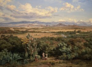
Photo Gallery

Route Features & Challenges
-
Relentless Ascent: The route is characterized by a near-constant, punishing climb from the park entrance to the summit, offering very few flat or recovery sections.
-
High-Altitude Effort: Starting at a significant altitude (around 3,000 meters or 9,800 feet) and climbing higher, the thin air makes breathing and pedaling considerably more difficult.
-
Mixed Terrain: The surface is a technical mix of broken pavement, loose gravel, and hard-packed dirt, requiring constant focus on bike handling and line choice.
- Steep Gradient Sections: Several sections of the climb spike to a very steep gradient (over 10-15%), demanding a low gear and significant core strength to avoid losing traction or stalling.
Points of Interest & Landmarks
-
Desierto de los Leones National Park: The ride takes place entirely within this historic and lush national park, a protected forest of towering oyamel fir and pine trees.
-
El Convento (The Convent): The starting point at the park entrance features a well-preserved 17th-century former Carmelite monastery, which now houses a museum and cafes.
-
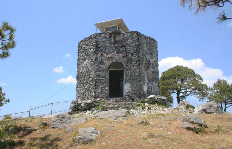
The “Monkey’s Face” Rock Formation: The summit is named for a distinct rock formation (Cerro Muñeco translates to “Doll Hill,” but locally known for a face-like rock) that offers a unique photo opportunity and a sense of accomplishment.
-
Summit Views: At the top, cyclists are rewarded with panoramic views of the sprawling Mexico City basin and the surrounding mountain ranges on a clear day.
-
Dense Forest Canopy: Much of the ride is shaded by the dense forest, creating a cool, serene, and almost mystical atmosphere that contrasts sharply with the physical exertion.
-
The “Pausa” (The Pause): An informal but well-known spot among local cyclists—a particularly steep, challenging pitch where riders often have to stop, dismount, or simply take a breather to appreciate the effort.
-
Altitude is the Primary Challenge: You will be riding above 3,000 meters (10,000 feet). The air is thin.
-
The Risk: Altitude sickness (dizziness, nausea, headache) and rapid exhaustion.
-
The Fix: Arrive early to acclimate. Ride within your limits. If you feel dizzy or sick, stop, descend immediately. Do not push through it.
-
-
Hypothermia Risk (Even on Sunny Days): The Desierto de los Leones is a humid, dense forest. You will sweat heavily on the climb, but the shaded mountain air is cold.
-
The Risk: On the descent, that wet jersey will turn freezing cold, leading to uncontrollable shivering and hypothermia within minutes.
-
The Fix: Carry a windproof/waterproof jacket in your jersey pocket. Put it on before you start descending.
-
-
Water is Scarce: There are no reliable water fountains or stores once you pass the entrance of the park.
-
The Risk: Severe dehydration, cramps, and heat exhaustion on the climb.
-
The Fix: Carry at least 2 large bottles (1.5L to 2L total) . If you are a heavy sweater, consider a hydration pack.
-
Las Kekas
San pedro Atlapulco (last pueblo before climb
Weather is inconsistent. High altitude
cold in the mornings and at high altitude, stay fresh. can get poured on
blah
blah
The Ideal Bike Setup
1. Bike Type: Gravel or Endurance Road
-
Gravel Bike (Recommended): Ideal for the mixed terrain. The wider tire clearance and more stable geometry inspire confidence on the loose gravel descents.
-
Endurance Road Bike: Suitable if it has tire clearance for at least 28mm or 30mm tires. A standard race bike with 25mm tires will be a very harsh, skittish ride.
2. Drivetrain & Gearing (Crucial for Survival)
-
The Requirement: You need a “granny gear”—a very low ratio for spinning up punishing gradients at high altitude.
-
The Setup:
-
Compact Crankset: 50/34t (standard) or even a sub-compact 46/30t.
-
Wide-Range Cassette: Ideally an 11-34t or 11-36t (or wider like 11-40t if your derailleur allows).
-
Warning: If you are riding a standard 53/39 crankset with an 11-25t cassette, you will likely have to walk, or you will blow your knees out.
-
3. Tires
-
Type: Gravel tires with a light center tread for rolling speed, but some side knobs for cornering grip on loose over hardpack.
Width: 40mm is the sweet spot. Minimum safe width is 32mm. (If you are on a road bike, run the widest tire your frame can fit).
Clothing & Hydration
-
Helmet: Non-negotiable.
-
Jersey: With at least three pockets.
-
Jacket: A windproof/waterproof gilet or jacket packed in that jersey pocket. (Repeated for emphasis—you will need this for the descent).
It is not advised to camp here. day route
Part 1: The Start – La Marquesa (Approx. 3,000m / 9,800ft)
-
The Vibe: You begin in the wide, windswept valley of La Marquesa, a popular recreational area. It’s exposed and often windy.
-
Action: Warm up on the flats or small rollers. Find the dirt trailhead that heads east towards the forest. You are leaving the open plains and heading for the trees.
Part 2: The Climb – The “Back Way” to Cerro Muñeco (Approx. 12-15 km)
This is the leg that separates the casual riders from the finishers.
-
Terrain: Dirt road, fire road, and rocky doubletrack. This is not the paved park road; this is the rugged, less traveled backside.
-
The Profile: You will be climbing almost immediately. It is a series of steep pitches and false flats.
-
Lower Slopes: Gradual but persistent climbing on hardpack dirt. You’ll start to feel the altitude here.
-
The Middle Section: The gradient kicks up. You enter the dense oyamel forest. The air gets cooler, and the ground may get damp or loose. This is where you need your low gears.
-
The Summit Push (Cerro Muñeco): The final kilometer to the high point is often the steepest and most technical. You may encounter loose rocks and roots. The reward is the summit area, marked by the distinctive rock formation and (on clear days) a view back over the valley you just climbed.
-
-
Time Estimate: 1.5 to 2.5 hours depending on fitness.
Part 3: The Ridge & Descent into Desierto de los Leones (Approx. 5-7 km)
You are now at the top. Stop here. Put on your jacket. The descent is cold.
-
Initial Descent: You will drop down the other side of Cerro Muñeco. This section is usually loose, fast, and requires full attention. You are now technically inside the Desierto de los Leones National Park boundaries.
-
The “Pausa” (The Pause): You will likely pop out onto a fire road and eventually intersect with the main paved park road. You might see the famous steep paved ramp known as “La Pausa” or “El Muro.” If you have the legs, you can attack it; most riders simply coast past it.
-
The Convento: As you continue descending the paved road, you will pass the iconic Ex-Convento del Desierto de los Leones. This is the historic landmark and a great photo op. There are also bathrooms and food stalls here—a perfect refuel stop.
Part 4: The Huixquilucan Exit (Approx. 8-10 km)
You are leaving the park, but you aren’t done with the climbing yet.
-
The “False Flat” Climb: From the Convento, you follow the main park road towards the Salazar/Huixqui exit. Don’t be fooled—while it trends downhill overall, there are several rolling punchy climbs that hurt tired legs.
-
The Gate: You will reach the park’s main entrance gate (the one on the Huixqui side).
-
The Technical Descent: Immediately after the gate, the pavement ends or turns into badly broken concrete/gravel. This steep, narrow, and bumpy track plunges down towards the town of Huixquilucan. Brake carefully. Loose gravel and cars are common here.
Part 5: The Return – Back to Huixquilucan (Approx. 5 km)
-
The Vibe: You exit the forest and are dumped onto the busy streets of Huixquilucan (Estado de México).
-
Action: This is a mix of urban riding. You will navigate traffic, speed bumps, and local neighborhoods. Follow the main road or your pre-planned route back to your starting point at La Marquesa, which will involve crossing under or around the highway.
Transportation
Resources
1 resrouce
2resource
3resource
4resource
Location Information
Learn more about the land this route travels through. Tap each location for more information.
📍 Geopolitical
⛰️ Geographic
🌿 Autonomous Land Acknowledgments
Ejidos and Indigenous Lineage
Route Development
Many recon rides with Paola Berber led to a deeper understanding of Desierto de Los Leones. However, many times to the first obelisco of the state lines of CDMX and Edo. Mex got me curious to find the trail to the peak of Cerro Muñeco.